Wilfred Hercy Dominick Whitlock (1898-1978)
Nat Map Driver (Survey) 1949
By Laurie McLean July 2021

Jerry Whitlock in 1949 circa age 51 years.
Extract from XNatmap image from Dave Hocking provided by Dave’s son Peter Hocking.
In 1949, Jerry Whitlock worked as a Driver (Survey) in a 3-person National Mapping astrofix field survey party that also included Dave Hocking (1920‑2000) and Eric Crisp (1929-2003). Another Nat Map astrofix field survey party under Ted Caspers (1912-1993) also operated in 1949. In various source documents WHD Whitlock is referred to as either Jerry or Gerry. In this XNatmap article, Dave Hocking’s spelling of Jerry is used except when quoting other sources. As discussed further below, the 1949 Nat Map field survey party was primarily undertaking astrofixes for planimetric mapping survey control in the Northern Territory.
Then about 51 years of age, Jerry Whitlock brought a wealth of experience to the 1949 field party that he had gained through an interesting life of varied pursuits:
· He was born in Sydney in 1898 where his English-born father practised as a dentist.
· His mother died when he was a few months old.
· At the age of 4 years, in 1902, Jerry and his 2 older siblings travelled to England escorted by a Miss Laura Cook.
· By the age of 17 years Jerry was farming in Alberta, Canada.
· By bumping-up his age, at 17 he joined the Canadian Overseas Expeditionary Force in World War I, served in England and France and was wounded by enemy action in both countries.
· After the War he worked as a surveyor in Canada and in California.
· He returned to Australia about 1936.
· He worked as a surveyor on the Darwin to Alice Springs road from the late 1930s.
· In 1941 and 1942, with a small team, he pushed 2 fire ploughed tracks generally westerly from the Stuart Highway across the Tanami Desert (Karlantijpa country) for defence purposes.
· In 1946, with his wife Ena, he established the Frewena roadhouse on the Barkly Highway east of Tennant Creek; the Whitlocks later divorced.
· From the mid-1950s Jerry Whitlock resided in Alice Springs undertaking building, earthmoving and track construction as well as operating a scrap metal and salvage yard.
Early life
Wilfred Hercy Dominick Whitlock was born in Sydney on 1 May 1898. His birth (No 15887/1898) was registered in the St Leonards district. From a newspaper advertisement for home help, it appears that in March 1898 Jerry’s parents resided in Victoria Avenue Chatswood, about 3 kilometres north of the present day St Leonards railway station in Sydney’s inner north.
Jerry was the youngest of the 3 children born to William Wilfred Lawson Whitlock (1871-1960) and his first wife Florence Bessie Curtis Whitlock née Walker (1864-1898). Jerry’s older siblings were his sister Dorothy May (1895‑1910) and brother Lawson Allen (1896-1982).
Jerry’s father William Wilfred Lawson Whitlock preferred the given name Wilfred. He and Florence Walker married in New South Wales on 25 October 1894. WL Whitlock practised as a dental surgeon from premises at 504 George Street Sydney.
As a youngster, Jerry Whitlock was known in his family as Hercy.
More about Florence Whitlock
Jerry Whitlock’s mother, Florence Walker’s birth was registered in the Thanet supplementary registration district for the July-September quarter of 1864. The Thanet Island district is in Kent to the south-east of London. The district includes the resort towns of Margate and Ramsgate. An 1871 England Census record showed that Florence was born at Ramsgate, Kent. Florence Walker was baptised on 6 August 1865 at the All Saints Church, Emscote that is now in Vicarage Field, Warwick, about 30 kilometres south-east of Birmingham. (The Emscote church that was standing in the 1860s was demolished in the 1960s due to structural issues.)
Florence was the first of the 7 children born to George Poole Walker (1843‑1895) and his wife Agnes Emily Walker née Beckwith (1839-1902). George Walker and Agnes Beckwith married on 27 September 1863 at the All Souls St Marylebone Church of England in London. In August 1865 George Walker was a photographer.
On the 1871 Census record, the Walker family resided at 15 Bedford Terrace Ealing in London’s west. As well as her parents, the record included 6-year old Florence and her siblings George (age 5), Laura (age 4),and Edith (age 1). George Walker was recorded as a photographer.
On an 1891 England Census record, the then circa 27 year old Florence Walker was recorded as a draper’s assistant residing at 150-158 Edgware Road in the St Marylebone district on the western edge of the City of London. A total of 58 people were recorded as residing at these premises including the head Charles Garrould (an accountant) and his son George (a buyer). The others included: 18 female draper’s assistants, 16 male draper’s assistants, 2 dressmakers, cooks, housemaids, a kitchenmaid, a mourning buyer, clerks, apprentices, porters, and a house carpenter. One of the male draper’s assistants in 1891 was Florence’s future husband Wilfred L Whitlock.
Garrould’s was founded in the 19th century as a general drapery emporium. By the 1890s it had expanded to occupy 3 different premises, in Edgware Road, Queen Street and Nutford Place and was a leading supplier of nurses’ uniforms and equipment. By the 1950s it had dwindled to a single building at the end of Harrowby Street and had become a general department store. Garrould’s closed in the 1960s as Marylebone was extensively redeveloped.
Florence Walker was listed as an unassisted passenger on the SS Ophir that arrived in Sydney from London on 23 February 1894. The then 29 year old Florence was not accompanied by any family member. However, her former work colleague and future husband, Wilfred Whitlock (senior), travelled on the same vessel; they married on 25 October 1894.
Sadly, Florence Whitlock died in North Sydney on 24 October 1898 nearly 7 months after her third child’s birth; she was 34 years of age. Her death was registered in the St Leonards district. Florence’s remains were buried at the Gore Hill Cemetery in Sydney’s inner north.
More about William Wilfred Lawson Whitlock
Jerry Whitlock’s father William Wilfred Lawson Whitlock was born on 11 February 1871 at Langtree, a village in north Devon about 300 kilometres west of London. The then 28 year old, Wilfred Whitlock (senior) was listed as an unassisted passenger on the SS Ophir that arrived in Sydney from London on 23 February 1894. As mentioned above, his former work colleague and future wife, Florence Walker, travelled on the same vessel; they married on 25 October 1894. As also mentioned above, the senior Wilfred Whitlock, was working as a London draper’s assistant in 1891 and practised as a dental surgeon in Sydney.
Sometime after the death of his first wife, Wilfred Whitlock (senior) returned to England. A record of this travel was not discovered during research for this article.
The 3 Whitlock children travelled to England in 1902 on board the SS Runic, a steamship built by Harland and Wolff in Belfast as a passenger liner for the White Star Line and entered service in 1901. Apparently, the Whitlock children, Dorothy (age 7), Lawson (age 6) and Hercy (age 4) were escorted on this voyage by a Miss Laura Cook (age 25 years). They departed Sydney on 24 June 1902 bound for London via the Cape of Good Hope. The Runic was then under the command of Captain D Thomas and was provisioned for a voyage of 56 days. (Laura Cook returned to Sydney on the Runic in April 1903.)
During the April-June quarter 1902, Wilfred Lawson Whitlock married Harriet Ellen Mary Batt (1870-1953) in the Tavistock district of west Devon, about 20 kilometres north of the Channel port of Plymouth. Harriet was born on 8 October 1870 in Exeter, Devon. There were no children from this marriage.
Sadly, in early 1910 Jerry’s older sister Dorothy May Whitlock died at age 14 years. Her death was recorded for the first quarter of the year in the St Pancras registration district in London.
On a 1911 English Census record, Wilfred Lawson Whitlock, dentist, (then age 40 years), together with his 2 sons resided at 531 Fulham Road, Fulham, about 8 kilometres south-west of the City of London. Both sons, Lawson Allen (14) and Wilfred Hercy (13) were recorded as students. The Whitlock household also comprised Violet Vaughan (age 32), domestic housekeeper; and 2 boarders, namely: Thomas Richmond (25) and George Stigant (21). Both boarders were high grade public servants with the Admiralty.
On another record for the 1911 Census night (2 April), Wilfred Lawson Whitlock’s second wife, Harriet Ellen Whitlock (then age 40 years) was visiting her parents John and Ellen Batt in East Dean, Gloucestershire. John Batt was a Uniting Methodist Minister.
On a 1925 UK Dentist Register, William (Wilfred) Lawson Whitlock resided at 501 Fulham Road London. On a 1939 England and Wales Register, Wilfred and Harriet Whitlock were retired and residing at The Warp, High Street, Romsey.
Harriet Whitlock died on 30 August 1953 at St Paul’s Hospital, Winchester. She left her effects to her husband and to her younger sister Annie Babbage.
William Wilfred Lawson Whitlock died on 7 March 1960 at St Paul’s Hospital, Winchester; he was formerly of The Wharf, Stockbridge, Hampshire. He left his effects to Donald Francis Nolder, a chartered surveyor.
Jerry Whitlock World War I service
By early 1916, Jerry Whitlock was residing in Canada and was using the Huxley Post Office as his address. Huxley is a rural hamlet in southern Alberta about 110 kilometres north-east of Calgary. As Hercy Whitlock, he enlisted in the Canadian Army at Calgary, Alberta on 20 March 1916 at the age of 17 years. His enlistment was for the duration of the War. As he was then too young to serve, Jerry claimed to be a year older by stating his birth was on 1 May 1897 rather than the actual 1 May 1898. Jerry stated that his previous occupation was a farmer and that his next of kin was his father who he made the sole beneficiary of his Will.
Jerry Whitlock served as a Private, No 736712, with the Canadian Overseas Expeditionary Force during World War I between March 1916 and 9 June 1919. He served in Canada from 20 March to 26 September 1916*, in England from 26 September 1916 to 10 November 1917, and in France from 11 November 1917 to 29 April 1919. (*Presumably 26 September 1916 was the day Private Whitlock departed Halifax for England.)
Private Whitlock departed Halifax, Nova Scotia on the SS Tuscania and arrived in England on 6 October 1916. He was initially taken on the strength of the Canadian 113th Reserve Battalion then stationed at the East Sandling Camp north-west of Folkestone on the coast and about 18 kilometres west of Dover in Kent.
The 14 350 gross tons, SS Tuscania was 173 metres in length. She was launched in September 1914 as a luxury liner for the Cunard Line subsidiary Anchor Line. Tuscania was requisitioned as a troop ship in 1916. On 5 February 1918, while transporting American troops to Europe and between the north of Ireland and Scotland en route from New York to Liverpool, she was torpedoed by German submarine UB-77 and sank with the loss of 210 lives.

SS Tuscania.
Image from Alchetron the Free Encyclopedia web site.
Service in England October 1916 – November 1917
In England, Private Whitlock was posted to the Canadian 17th Infantry Battalion on 8 October 1916. He was in the Canadian Casualty Assembly Centre, attached to the 17th Battalion on 14 November 1916.
From 22 December 1916 to 7 August 1917, Private Whitlock was posted to the Canadian Army Service Corps at Shorncliffe, about 6 kilometres east of Sandling. On 14 March 1917, he suffered a dislocated right collar bone in a fall and was initially treated at the Canadian Convalescent Hospital at Bromley. A few days later, treatment continued at the Canadian Convalescent Hospital at Woodcote Park, Epsom.
German air raid at Shorncliffe May 1917
On 25 May 1917, Private Whitlock suffered a shrapnel wound to the head (lacerated wound to scalp) during a German air raid at the Shorncliffe camp. His wound was treated at the Moor Barracks Hospital at Shorncliffe.
That day, a squadron of 21 Belgium-based German Gotha G. IV heavy biplane bombers launched an attack on London, However, due to thick cloud the raiders turned south to Kent and the area around Folkestone. The Germans approached from the west and attacked Hythe and Cheriton.
The Germans then bombed the Army camp at Shorncliffe and finally attacked the Folkestone town centre where the majority of the high explosive bombs were dropped. No air raid warning was given and the surprise early evening attack caused the deaths of 79 civilians with scores injured in the Tontine Street area, many of the civilian casualties were women and children. At the Shorncliffe camp 18 soldiers, 16 of them Canadians, were killed and Private Whitlock was among the 90 soldiers injured.

A World War I German Gotha G. IV heavy bomber.
Image from Canada War Graves web site.
On 8 August 1917, Private Whitlock was posted to the Nova Scotia Regimental Depot at Bramshott. He was posted to the Canadian 17th Reserve Infantry Battalion, also at Bramshott, from 13 August to 10 November 1917.
Service in France November 1917 – April 1919
On 11 November 1917, Private Whitlock was posted to France with the 85th Canadian Infantry Battalion, which was known as the Nova Scotia Highlanders.
In October 1917, the 85th Battalion was in the Ypres Salient in Belgium as the Canadian Corps prepared to attack the German positions along the Passchendaele ridge. The 85th Battalion was in the third phase of the attack from 28 October to 2 November 1917. On the night of 28 October 1917, German infantry launched an assault and seized a strategic portion of the front line. The 85th Battalion’s D Company, succeeded in recapturing the trench at a decisive point and the existing front line was held.
Two days later, the 85th Battalion’s A, B and C Companies were in the advance on Passchendaele village. D Company remained in support and entered the fight at a crucial moment to turn the tide in favour of the attacking forces. While the 85th Battalion succeeded in securing its objectives, the costs were considerable. Of the 26 Officers who entered the line at Passchendaele, 12 were killed and 8 wounded, while 371 of the 662 other ranks who entered the trenches on 28 October were casualties by the time the Battalion retired from the line on the night of 31 October-1 November 1917.
It was most likely to reinforce the Battalion after these high casualties that Private Whitlock was posted on 11 November 1917. Around that time, the Canadian Corps had 4 Divisions each with Divisional Ammunition Columns. The 4th Canadian Division comprised the 10th, 11th, and 12th Canadian Infantry Brigades (each with 4 Infantry Battalions and a Trench Mortar Battery) and the 4th Brigade Canadian Engineers. The 12th Canadian Infantry Brigade comprised:
· 38th Canadian Infantry Battalion
· 72nd Canadian Infantry Battalion
· 78th Canadian Infantry Battalion
· 85th Canadian Infantry Battalion
· 12th Trench Mortar Battery.
Throughout 1918, the 85th Battalion served with distinction, including in the major battles at Amiens from 8 to 11 August 1918; Arras from 2 to 5 September 1918; and Cambrai 25 September to 2 October 1918; during what was later called Canada’s 100 Days.
The image below shows Canadian troops on the Arras to Cambrai road near Arras on 1 September 1918. On the left is the Scarpe River and the tracked vehicle is a Renault FT17 light tank. The French town of Arras is about 170 kilometres north of Paris and about 45 kilometres from the Belgium border. Cambrai is about 35 kilometres south-east of Arras.

Canadian troops near Arras 1 September 1918.
William Rider-Rider photograph from Library and Archives Canada, reference number PA-003153.
During the 96 days from 8 August until 11 November 1918, as part of the British First Army, the Canadian Corps fought in the Battle of Amiens, the Second Battle of the Somme, the Battle of the Scarpe, the Battle of the Canal du Nord, the Battle of Cambrai, the Battle of the Selle, the Battle of Valenciennes and lastly at Mons on the final day of combat prior to the Armistice on 11 November 1918. In those 100 days, the 4 Canadian Divisions totalling roughly 100 000 men, engaged and defeated or put to flight elements of 47 German divisions. However, the Canadian Corps suffered over 45 000 casualties during this period.
During fighting near Arras on 2 September 1918, Private Whitlock suffered a gun shot wound to his right shoulder, neck and face. Initially, he received treatment at 18th General Hospital at Camiers near the English Channel coast about 90 kilometres north-west of Arras. Treatment continued at various facilities over the next 2 months. The 18th General Hospital was then run by United States forces. On 4 November 1918, he was posted to the Canadian Infantry Brigade Depot at Étaples about 6 kilometres south of Camiers.
Private Whitlock rejoined the 85th Battalion on 5 December 1918. He remained with the Battalion until posted to England on 29 April 1919. He then proceeded to Canada on 31 May 1919 and was discharged from the Canadian Army in Halifax on 9 June 1919.
London Electoral Registers 1918 and 1919
Despite serving in France between November 1917 and May 1919, Wilfred Hercy Dominic (sic) Whitlock together with his brother Lawson Allen Whitlock was listed on London electoral registers for both 1918 and 1919. They were listed at 501 Fulham Road Fulham. However, the Whitlock brothers’ father and step‑mother were not listed on these registers. Jerry Whitlock’s listing on these registers appears to be an anomaly.
In Canada and the United States after World War I
Jerry Whitlock’s initial civilian address after discharge from the Canadian Army in June 1919 was 827 – 5th Avenue Calgary, Alberta. During the 1920s, he worked as a land surveyor at Lethbridge in southern Alberta that is located to the east of the Rocky Mountains about 170 kilometres south-east of Calgary and about 75 kilometres north of the United States border.
Later Jerry Whitlock worked as a licensed surveyor in California, until it was discovered that he was not a United States citizen. From 4 December 1930, his address with the Canadian Army was care of the Canadian Legion, British Empire Service League, 217 La Arcada Building Santa Barbara, California.
During the Great Depression years of the 1930s, the United States Coast and Geodetic Survey developed a plan to create up to 15 000 land surveyors and engineers jobs through the Federal Emergency Relief Administration. Also in the 1930s, the now Board for Professional Engineers, Land Surveyors, and Geologists in California was given the legislative authority to license land surveyors. These events may have highlighted that Jerry Whitlock was not a United States citizen.

La Arcada building and courtyard, Santa Barbara circa 1926.
Image from Los Angeles Times Photographs Collection on University of California web site.
Return to Australia circa 1936
According to some material on Ancestry family tree entries, Jerry Whitlock returned to Australia about 1936. Jerry’s return was after an absence of some 34 years from when as a 4-year old he travelled to England with his 2 older siblings and a Miss Laura Cook. After his circa 1936 return, Jerry was to remain in Australia for the rest of his life.
Road surveying in the Northern Territory from the late 1930s
Between 1932 and 1951, the Department of the Interior was the Commonwealth Government department responsible for administering the Northern Territory. During this period, various entities were created to administer the Territory, including a Department of the Administrator (early 1930s), a Northern Territory Administration Section (late 1930s) and a Northern Territory Administration Branch (mid-1940s). Other Commonwealth entities undertook the various functions of government. For example, between 1932 and 1946 civil works were undertaken by the Works and Services Branch, Northern Territory. General lands and property surveys were undertaken by the Lands and Survey Branch between 1931 and 1972.
Following the first Japanese attack on Darwin on 19 February 1942, military control was imposed over parts of Australia and its Territories. On 21 February 1942, the Northern Territory north of Birdum was placed under military rule; as well as Cape York Peninsula in North Queensland and the Kimberley region of Western Australia. This military control also included the Australian Territory of Papua New Guinea and was invoked under the National Security (Emergency Control) Regulations 1941. Until after the War, civilians required passes to enter these areas. From 1 March 1942, Alice Springs became the centre for the civil administration for the Northern Territory.
By no later than 1938, Jerry Whitlock was a public servant in the Northern Territory undertaking surveys for the making of an all weather road from Darwin to Alice Springs. Unfortunately, he was not listed as a public servant in Commonwealth of Australia Gazettes in the 1930s or the 1940s. His obituary in the Centralian Advocate, stated that Jerry Whitlock surveyed for the construction of the new road between Tennant Creek and Birdum in the early years of the war.
During 1938 to circa mid-1939, Jerry Whitlock was surveying for the new road alignment in the Adelaide River area about 110 kilometres or so south of Darwin. On this part of the survey, at least, Whitlock was working with civil engineer Herbert Kevin (Kevin) Graham and assistant James Barclay Watts (1913-1992). James Watts believed Whitlock was an American; see Appendix A.
The Adelaide newspaper News of 24 August 1940 reported that: a survey of the proposed route has just been completed by a party of engineers including Major Dickson, of the Military Survey Corps, and representatives from the States.
Forming the road from Tennant Creek to Larrimah became a military priority in August 1940 and the work was undertaken by construction teams from the South Australian Highways Commission, the Queensland Main Roads Commission and the New South Wales Department of Main Roads. Concurrently, the Department of Interior carried out improvements on the road between Alice Springs and Tennant Creek.
As part of the transport infrastructure upgrade, the southern terminus of the Northern Australia Railway was moved from Birdum to Larrimah, some 9 kilometres to the north. Unlike Birdum, Larrimah was on the North-South road (later named the Stuart Highway). The new road to the railhead at Larrimah was completed by December 1940 and was ready for the first military convoy early in 1941. Owing to its strategic significance, the decision was made in 1942 to strengthen and to seal the road between Larrimah and Alice Springs as well as the road from Tennant Creek to Mount Isa.
Unverified reports in Ancestry family tree entries suggest Jerry Whitlock’s Northern Territory road surveying extended between Alice Springs and Darwin. It was claimed that his proposed route from Katherine to Darwin was not used initially as it by-passed Pine Creek. However, this route was subsequently adopted as it required only one bridge and was about 30 kilometres shorter. Jerry Whitlock was also reported as having a role in selecting the original site for the Three Ways junction of the Barkly and Stuart Highways. The junction has since been shifted about 600 metres to the south.
Marriage to Ena Lucas 1941
Jerry Whitlock and Ena Lucas (née Colquhoun) married in Sydney on 23 May 1941. It was Ena’s second marriage; she was about 33 years of age and Jerry was 43 years old. For around 7 months in 1941, Jerry Whitlock was working in the remote Tanami Desert in the Northern Territory. From research for this article, it appears that Ena accompanied Jerry on this 1941 work and was most likely with his field party again in the Tanami during 1942.
About Ena Whitlock
Mary Ena Colquhoun was born in 1907 at the inner south-western Sydney suburb of Marrickville. Ena was the first of the 6 children born to John Vincent Colquhoun (1885-1924) and his wife Johanna Ann (Dolly) Colquhoun née Wheeler (1887-1976). When Ena’s father died in 1924, the family was living at Bexley. By the early 1930s, her mother was living at nearby Rockdale.
In July 1928, Ena Colquhoun and Richard Henry Lucas (1902-1971) married at Rockdale in inner south-west Sydney. Over the next few years Ena and Richard Lucas resided at Banksia near Rockdale (1930) and at Bondi (1931 and 1934). In 1930 and 1931, Richard was occupied as a turner and in 1934 as a furrier. During these years Ena was occupied in home duties. However, their marriage did not endure and in early 1938, Richard Lucas petitioned for divorce on the grounds of Ena’s desertion. On 19 October 1938, the Sydney Morning Herald newspaper reported that in the Supreme Court, Mr Justice Boyce had granted a decree absolute thus formally dissolving Ena and Richard’s marriage in divorce.
From around 1936, Ena Whitlock was residing at Rockdale and working as a wine steward at the prestigious Australia Hotel that operated from 1891 to 1971 in Castlereagh Street Sydney.
In August 1951, Ena Whitlock advertised the Frewena Roadhouse for sale with an asking price of £4 000 cash, for more details see Appendix D. On 2 November 1951, the Darwin Northern Standard newspaper reported that Mrs Gerry Whitlock late of Frewena and a Mrs Neilson had left that morning on their way south after staying at the Hotel Darwin; presumably by then Ena had concluded the sale of Frewena.
From electoral rolls, in 1954 and 1958 Ena Whitlock was listed as residing at Horseshoe Bay (on Magnetic Island off-shore from Townsville) and being occupied as a pineapple farmer. For the years 1963, 1968 and 1972, Ena Whitlock was listed as residing at separate addresses in Mt Isa; initially she was engaged in home duties and for the last 2 listed years as a cleaner.
Further mention of Ena Whitlock was not discovered on later electoral rolls nor was a death notice for her found during research for this article.
Defence tracks across the Tanami (Karlantijpa country) 1941 and 1942
During 1941 and 1942, Jerry Whitlock led field parties of about 6 other people to construct 2 tracks across the Tanami Desert (Karlantijpa country) for defence purposes. Most likely, the 2 tracks were established as a contingency in case the evacuation of livestock (and possibly, people) became necessary following invasion or other hostile actions by Imperial Japanese forces.
During World War II, Japanese aircraft attacked Darwin on 64 occasions, the first was on 19 February 1942. The following day, the Western Australian State Shipping Service MV Koolama was bombed. This attack occurred near Lesueur Island in the Timor Sea off the mouth of the King George River. The 4 068 gross register tons Koolama sank at Wyndham on 3 March 1942. Subsequently, the Commonwealth and Western Australian Governments decided to refurbish the Canning Stock Route.
With the potential loss of coastal shipping, the Canning Stock Route which then ran for about 1 800 kilometres from Billiluna to Wiluna across the Great Sandy and Gibson Deserts was seen as a suitable route for moving Kimberley cattle to the south. Refurbishment of the 50 or so wells on the Stock Route was carried out mainly by the Kalgoorlie Water Supply during 1942-1944.

The Whitlock 1941-1942 defence tracks through Karlantijpa Aboriginal Country.
The 2 Whitlock tracks were highlighted in green by Paul Wise in 2021.
Base map extract from: HEC Robinson Pty Ltd Northern Territory Road Map 1953.
National Library of Australia object no 234121977.
The 2 Tanami tracks that Jerry Whitlock established are shown on the map above. When establishing these tracks, it seems likely that Jerry Whitlock was employed by the Department of the Interior or another Commonwealth Government Department in the Northern Territory.
Southern track 1941
Jerry Whitlock’s first (or southern) track, across Karlantijpa country was constructed during 1941. As depicted earlier, in the tracks map, the 1941 track ran from the Three Ways junction about 24 kilometres north of Tennant Creek to near Granny Soak on the Western Australia border about 80 kilometres south‑east of Gordon Downs Homestead; and about 100 kilometres north-west of Tanami Bore. Whitlock’s 1941 track covered a total distance of about 610 kilometres.
As detailed in Appendix B, Ena Whitlock was a member of the 1941 track construction party of 7 people. She made camp twice a day, cooked for the six men and rode on a tractor. The party also included a tractor that pulled a fire plough as well as support trucks. An obituary for Jerry Whitlock published in the Alice Springs weekly Centralian Advocate stated that the final 240 kilometres of this track was made using only compass bearings for direction. It was also stated that over this final distance the tractor pulling the fire plough had to operate in reverse as it had lost its low forward gear.
As indicated by the Department of the Interior sign in the image below, the southern Whitlock track was over country without reliable sources of water. The image below was taken in 1948 near the eastern end of the track by Nat Mapper Dave Hocking.
Presumably, the image was taken when Dave and fellow Nat Mapper Don McKay (1921-1999) were undertaking astrofix observations for mapping control in that area circa October 1948. Around that month Dave Hocking observed astrofixes NMH 59 to NMH 61 about 30 or more kilometres west of the Three Ways junction.

Department of the Interior sign near the eastern end of Whitlock’s 1941 track.
A 1948 XNatmap image by Dave Hocking provided by Dave’s son Peter Hocking.
One of the people working in the 1941 track construction party was Francis Oliver (Frank) Glastonbury (1915-1984).
Frank Glastonbury served as a Private in the Militia Forces from April 1942 to December 1943, Service Number S112447. Frank enlisted at Alice Springs and when discharged he was serving with the 16th Maintenance Platoon, Royal Australian Engineers. Frank worked in various occupations, including as a grader operator, well borer, carpenter, and gold prospector.
In the mid-1970s, together with Sam Griffiths an Alice Springs butcher, Frank Glastonbury, jointly held 11 small gold mining leases (contiguous tenements each 400 metres square that covered old workings as well as geologically interesting outcrops). The leases were at The Granites about 540 kilometres north-west of Alice Springs. These Gold Mining Leases (GMLs 60 to 70 inclusive) had lapsed but Glastonbury and Griffiths were jointly to receive $50 000 on transfer of the leases to North Flinders Mines Ltd that was to apply for the leases to be reinstated. In August 1976, the Mining Warden in Alice Springs recommended the grant of GMLs 60 to 70 to North Flinders Mines Ltd. Since 2002, The Granites Gold Mine has been operated by Newmont Mining (a subsidiary of the United States Newmont Corporation).
Department of the Interior DE level traverse 1964
During June, July, and August 1964, Canberra-based Survey Technical Officers Norman Francis Vaughan and Carlos Pereira de Lemos* from the Survey Branch of the Department of the Interior led small field survey parties to undertake a third order levelling traverse over some of the country covered by Jerry Whitlock’s 1941 southern track. This level traverse, designated DE, was undertaken for the Geophysical Branch of the Bureau of Mineral Resources, Geology and Geophysics as part of the Bureau’s oil search program. Messrs Vaughan and de Lemos undertook other level traverses in the Tanami during 1964, including the DD and DJ traverses.
*(Dr de Lemos later held academic positions at the Royal Melbourne Institute of Technology and Monash University. He was awarded the Medal of the Order of Australia in 2018 for his service to the Portuguese community of Victoria. He was the Honorary Consul for Portugal in Melbourne from 1988 to 2019.)
From bench-mark DI 54, the DE level traverse ran generally west for about 470 kilometres to terminate at bench-mark BP 13 about 90 kilometres north of Tanami on the Tanami to Hooker Creek track. There were 57 bench‑marks along the DE traverse (numbers DE 03 to DE 59 inclusive). These bench‑marks were roughly 8 kilometres apart. The 1964 DE traverse description compiled by Messrs Vaughan and de Lemos mentioned sightings of Whitlock’s 1941 track on several occasions as shown in the table below.
|
Bench-Mark |
Speedo reading miles (km)* |
Whitlock-related comments |
|
DE 18 |
82.2 (132.3) |
|
|
|
86.3 (138.9) |
Whitlock’s 1941 track follow west down hill |
|
DE 19 |
86.5 (139.3) |
North of Whitlock’s track |
|
|
90.2 (145.2) |
Whitlock’s track across ironstone ridge |
|
DE 20 |
91.9 (148.0) |
North of Whitlock’s track (faint) |
|
DE 21 |
96.4 (155.2) |
North of Whitlock’s track on low ironstone rise |
|
|
100.8 (162.3) |
Follow well defined tracks to north-west |
|
DE 24 |
113.7 (183.1) |
Follow tracks to right |
|
DE 26 |
125.1 (201.4) |
South of tracks |
|
|
126.7 (203.9) |
Turn left off main tracks |
|
DE 40 |
194.1 (312.5) |
0.2 miles south of Whitlock’s tracks |
*Speedo readings indicate the distance from the traverse start point on the Stuart Highway.
Sightings of Whitlock’s southern track in 1964.
Extract from DE traverse description kindly provided by Dr David Nash.
As shown in the diagram below, the DE traverse ran over the Tennant Creek, Green Swamp Well, Tanami East, and Tanami 1:250 000 scale topographic map sheet areas.

The extent of the DE level traverse.
An edited extract from Plate 4 in Flavelle, Alan J (1965).
Chewings’ 1909 Barrow Creek to Victoria River stock route
Charles Chewings (1859-1937) was born near Burra in South Australia. In 1891 he commenced study in geology at the University College, London and continued at the University of Heidelberg, Germany where he was awarded the degree of Doctor of Philosophy in 1894.
In 1909, with 3 white and 2 Aboriginal companions and a caravan of 20 camels, Dr Chewing surveyed a stock route across the eastern Tanami from the Barrow Creek Overland Telegraph Station to Victoria River. This work was undertaken for the South Australian Government.

Map of Dr Charles Chewings’ 1909 journey.
From Chewings (1930).
Dr Chewing’s party sunk 10 wells along the route using light boring equipment transported on the party’s camels. Although, Dr Chewings had proved the availability of water at shallow depth, there was insufficient feed for a viable stock route.
One of Chewings’ wells was located in a green swamp at about 19° 29’ South 132° 18’ East. Dr Chewings described it as: in sandstone rock, depth 6'0", size 5'0" X 3'0" makes at rate of 1,728 gallons in twenty four hours. Dr Chewings named this well Green Swamp Well and this name was later used for the related R502 series 1:250 000 scale topographic map sheet.

A green swamp near bench-mark DE 21 in theTanami Desert in 1972.
Image kindly supplied by Nat Mapper Alan Deck.

A valley of gums near the DE level traverse in the Tanami Desert in 1972.
Image kindly supplied by Nat Mapper Alan Deck.
DE traverse levelling survey operations
On their 1964 DE traverse levelling survey, Norman Vaughan and Carlos de Lemos were the observers and operated independently; each using a Watts Autoset level. Each sub-party had 2 chainmen and 2 Land Rover 4-wheel-drive vehicles. The technical officer observed the levelling staff held by each of the chainmen, one about 100 metres to the rear of the observer and the other about 100 metres in front of the observer.
When the rear staff had been observed, that chainman then drove to the observer while the forward staff was being observed, and then moved the observer about 200 metres forward along the line of the traverse. The observer then re-set his level and observed the new rear staff, and that leap‑frogging process continued throughout the working day.
About every 8 kilometres or so along the traverse the levelling party established a permanent concrete bench-mark with a star picket witness post nearby. The observers also accurately annotated the positions of the bench-marks on aerial photographs.

A Department of the Interior bench-mark and witness post.
An XNatmap image.
The 1964 DE traverse levelling parties operated in the field for about 3 weeks at a time. They then returned to their base camp at Banka Banka that had 2 other field party members, namely a cook and a mechanic. The levelling sub-parties remained at their base camp for about a week. Here the observers reduced their field observations and carried out related calculations. Proper showers, clothes washing and other personal functions were attended to and any necessary repairs were made to the vehicles and equipment before returning to the field work.

Carlos de Lemos examining the lens of a Watts Autoset level in the Tanami Desert.
1964 photograph kindly provided by Dr Carlos de Lemos.
Later gravity survey
In June 1965, Sydney-based BMR contractor Wongela Geophysical Pty Ltd carried out a helicopter-borne gravity survey over the DE traverse as part of a larger gravity survey that extended from the Western Australia border and to the east of Normanton and Cloncurry and south from Daly Waters to Alice Springs.
A national gravity base-station was established at the Vaughan Airstrip near bench-mark DE 50 on the DE level traverse. Designated Vaughan Airstrip 38390 (its International Gravity Commission identification number), this national gravity base station was used to control the gravity datum for the local gravity surveys; it was located at 19°10´.6 South 130° 49´.6 East. The Bureau of Mineral Resources gravity station number at bench-mark DE 50 was 6491.9056. This gravity station number indicated that the national gravity base station was established in 1964 prior to the Wongela gravity survey. For more information on Vaughan Airstrip, please see Appendix E.
Jerry Whitlock’s second or northern track across Karlantijpa country was made during 1942. It ran from the Government Muckaty Bore to Wave Hill and was about 400 kilometres (250 miles) in length. Muckaty Station (Pastoral Lease 856) had an area of about 2 240 square kilometres, most of which was on the western side of the Stuart Highway. The Station was developed from 1945, by Yorkshire-born Alfred Cecil Beresford (Fred) Ulyatt (1903-1975) and his Pine Creek-born wife Mary Ellen (May) Ulyatt née O’Shea (1910-1976).
Fred Ulyatt and May O’Shea married in Birdum in September 1939 a few days after World War II was declared. Prior to their marriage Fred was working as a storekeeper at Birdum and May was managing the office at the Birdum Hotel for her father, Tim O’Shea who also owned hotels at Katherine and Borroloola. Fred and May Ulyatt were to have 3 daughters; Miriam born 1940, Patricia born 1941, and Lois born 1948.

Birdum Hotel on 31 December 1951, it was shifted to Larrimah in 1952.
From Ena Ryan Collection on Territory Stories web site.
When Fred Ulyatt first came to the Territory in the late 1920s he was keen on acquiring the Eva Downs Pastoral Lease of about 2 800 square kilometres on the northern Barkly Tableland. However, by the time he was ready to register a claim for this property in early 1939 Fred found that Sidney Chambers had made a claim for it only on the previous day. Instead, Fred then decided to try for Muckaty which he obtained; initially on a grazing licence and later on a 99‑year lease.
The War had major impacts on the Ulyatts’ lives. Fred was seconded for the duration by the Allied Works Council and put in charge of gangs of workers for the Department of Civil Aviation establishing emergency landing strips. This work was over a huge area of the Northern Territory, from Darwin to Wave Hill on the west of the Stuart Highway. Fred was away from home for long periods.
After the first bombing of Darwin in February 1942, women and children had to evacuate from the Territory’s Top End. Initially May Ulyatt and her 2 very young daughters stayed at Helen Springs Homestead. But in August 1942, Tim O’Shea brought his eldest daughter May and his 2 young grandchildren, Miriam and Patricia, to Muckaty. This was in the same year that the Whitlock track to Wave Hill had been made.
At Muckaty, May and her daughters didn’t have much to start with. Tim O’Shea set them up in a tent beside a well. May and her children had no refrigeration, no vehicle and no telephone. Essentially May was alone. Fortunately an elderly stockman, Harry Condon, came to spent his final years at Muckaty. Harry helped out by drawing water, establishing a vegetable garden, and tending a small goat herd for milk and meat.

Old Muckaty Homestead circa 1960.
Image kindly provided by Miriam Hagan.
Fred Ulyatt was released by the Allied War Council in 1945 and immediately returned to stock and establish Muckaty. The Ulyatts put in long, hard hours over many years developing their property, building fences, yards, creek crossings, tracks etc as well as building up their cattle herd and coping with droughts. Eventually, Fred’s health began to decline and the Ulyatts retired to Alice Springs. In 1963, the Ulyatts’ eldest daughter Miriam and her husband Allan Hagan purchased and ran Muckaty for the next 25 years. The Hagans sold the lease in 1988. Muckaty is now held as Aboriginal freehold land by the Muckaty Aboriginal Land Trust.
Miriam Hagan was an infant when Jerry Whitlock and his party made the track from Muckaty to Wave Hill. However, Miriam recently recalled that the fire‑plough road commenced on Muckaty’s desert boundary, west of Latapa as the local indigenous people pronounced this site.
Her Dad and Mum said that 44‑gallon drums of water were dropped off along the route the work-party was to take, since no-one knew of any permanent water. Miriam advised that the terrain over which the Whitlock track passed was mainly a few low, gravel hills, red sandy soil and vegetation included low turpentine and conkerberry shrubs, sparse coolabah trees and spinifex, spinifex, spinifex!
Miriam Hagan added that local Aboriginal people were very nervous about venturing west of Latapa* because of a tribe they referred to as Warlamarla (warrmarla or warriors - Nash, 1992) who ranged far away across the desert on the Wave Hill side. The locals lived in great fear of them, always alert to the west and always home in their own encampment by nightfall. The local Aboriginal people spoke of the Whitlock road in pidgin as Pup’lo Rote (Fireplough Road) and eventually the locals called it Buffalo Road.
*Ladabah (or Latapa) is a site near the Ladabah Bore shown on the map extract below; the bore is on the south side of Tomkinson Creek about 28 kilometres west of Muckaty Homestead. Tomkinson Creek was named by John McDouall Stuart on 27 April 1861 after Samuel Tomkinson (1816-1900) a prominent Adelaide businessman, banker and politician.

Tanami (Karlantijpa) country about 80 kilometres west of Ladabah Bore at NM/G/136.
August 1992 image kindly provided by Dr David Nash.
Miriam Hagan also recalled that her parents knew Gerry and Ena Whitlock and visited occasionally when they ran the Frewena Roadhouse on the Barkly Highway.
Whitlock’s track construction party used a fire plough towed behind a tractor to push the track across the Tanami. The party also had some support trucks to carry personnel, fuel, water, food supplies, camping equipment and other necessities.
In a 1965 conversation with Nat Map Supervising Surveyor (Geodetic) Howard Angas (Bill) Johnson (1907-1990), Gerry Whitlock recalled that during his Tanami track marking days some of his party members were concerned about the tough conditions. You will perish us all, was apparently one concern; of course an outcome that did not eventuate.
The image below was taken in June 1992 on Muckaty Station. It shows local men and Dr Peter Sutton inspecting a New Holland brand fire plough. This machine was purchased from Queensland Pastoral Supplies by Fred Ulyatt circa 1948 and used extensively on Muckaty; mainly for grading fire breaks around fences, and lightly scraping the surface of station tracks. This fire plough is thought to be similar, at least in concept, to the earlier machine used by Jerry Whitlock to make his tracks across the Tanami in 1941 and 1942.

A New Holland fire plough on Muckaty Station in 1992.
Image taken and kindly supplied by Dr David Nash.

Muckaty Station track to Ladabah Bore.
Extract from SE53-10 Helen Springs 1959 Provisional Edition R502 map sheet, 1975 reprint.
Living in Alice Springs 1943
On a 1943 electoral roll, Mary Ena Whitlock and Wilfred Hercy Whitlock were listed as residing at Alice Springs and being engaged with home duties and as a civil engineer, respectively. This was the earliest electoral roll listing of the Whitlocks that was discovered during research for this article.
Oberon gold mining lease circa 1944-1947
In the Government Gazette of the State of New South Wales on 28 February 1947, notice was given of the cancellation of a gold mining lease over 9 acres of land (portion GL 46) in the parish of Oberon. The cancellation was due to failure to fulfil the covenants and conditions of the lease which was in the names of Wilfred Hercy Whitlock and Herbert Stanislaus Walsh.
Gold was first discovered in the Oberon area in the 1820s. The Oberon gold field was mainly to the north and west of the township which is on the western side of the Blue Mountains about 40 kilometres south-east of Bathurst.
Research for this article did not discover when Jerry Whitlock became a party to this gold mining lease. However, the subject lease was granted to John Joseph Byrne and Herbert Stanislaus Walsh on 19 June 1936. On 20 June 1944, an application by Herbert Stanislaus Walsh for the granting of the lease solely in his name was refused. Presumably Jerry Whitlock became a party to the lease some time later. It is not known if Jerry Whitlock was ever personally involved in the working of the lease.
Frewena Roadhouse 1946-1948
In 1946, Jerry and Ena Whitlock established the Frewena Roadhouse on the Barkly Highway in the Northern Territory. The name Frewena was derived from the Frew River and Ena (Mrs Whitlock’s second given name). The Frew River rises in the Davenport Range about 170 kilometres or so south of Frewena and runs generally northward to discharge on to the Barkly Tableland about 60 kilometres or so to the south-east of Frewena.
As detailed in Appendix D, Jerry Whitlock purchased many of the Bore 6A staging camp buildings and other infrastructure from the Commonwealth Disposals Commission in early 1946. His purchases totalled some £412. However, as also detailed in Appendix D, Jerry Whitlock did not buy all of the Bore 6A camp buildings.
Jerry and Ena Whitlock operated the Frewena Roadhouse together between 1946 and 1948. In 1948 Jerry sold his interest in the roadhouse to Ena and left the district. Jerry and Ena later divorced. However, on a 1949 electoral roll both Mary Ena Whitlock and Wilfred Hercy Whitlock were listed as residing at Frewena via Tennant Creek, with both engaged as shopkeepers. Apparently, this roll may have been out of date in respect to Jerry Whitlock.
The Centralian Advocate on 23 January 1948 reported that Mrs Ena Whitlock of Frewena was then staying at Underdown’s Hotel in Alice Springs.
Ena Whitlock continued operating the roadhouse until late in 1951. Ena advertised the Frewena Roadhouse for sale in August 1951 with an asking price of £4 000 cash. As mentioned previously, in October 1951, Ena Whitlock left the Northern Territory.

Location of Frewena Roadhouse, Barkly Highway Northern Territory.
Extract from E53-15 Alroy 4 Mile Topographic Series, Provisional Edition, August 1959.

Location of Nat Map’s first survey station – NM H1.
It was established at Frewena by Dave Hocking on 21 May 1948.
Diagram from Hocking, (1985).

Frewena Roadhouse, Barkly Highway Northern Territory in 1969.
XNatmap image provided by Ian Ogilvie.
1949 National Mapping astrofix field parties Northern Territory
During 1949, Jerry Whitlock was a member of one of the two Nat Map astrofix field survey parties that operated mainly in the Northern Territory. Specifically, these field parties operated on the Barkly Tableland, in the Gulf of Carpentaria district and around the Harts Range area in Central Australia. The two field parties initially comprised:
· David Roy (Dave) Hocking, Survey Computer and OIC Field Operations
· Alfred Eric (Eric) Crisp Cadet Draftsman (Canberra-based)
· Wilfred Hercy (Jerry) Whitlock Driver (Survey)
· Edward John (Ted) Caspers Field Assistant (Survey) Party Leader
· Donald (Don) Graham Driver (Survey) to mid-September 1949.

1949 Nat Map astrofix field parties north-bound at Quorn.
From left: Jerry Whitlock, Ted Caspers, Don Graham, Dave Hocking, and Eric Crisp.
Dave Hocking image provided by Dave’s son Peter Hocking.
The 2 survey parties were in the field for about 6 months. They departed Melbourne around May 1949 and drove in 3 vehicles to Quorn in the Flinders Ranges about 40 kilometres north-east of Port Augusta in South Australia. At Quorn, the vehicles were loaded on to a flat-top rail wagon for the rail journey to Alice Springs on the (old) Ghan narrow gauge steam-powered train. This rail journey avoided driving over more than 1 200 kilometres of then poor quality, unsealed road between Port Augusta and Alice Springs that tended to be fairly harsh on vehicles.

The north-bound 1949 Nat Map field party vehicles at Quorn.
Dave Hocking image provided by Dave’s son Peter Hocking.
Field party members Dave Hocking, Ted Caspers, Eric Crisp and Bill Stroud, left Alice Springs homeward bound by train on Monday 7 November 1949. Jerry Whitlock did not travel with them and apparently left the field party while still in the Northern Territory.
Donegan - Aboriginal guide
Another member of the field party was Donegan, an Aboriginal man, who had been a Police Tracker at Borroloola in the early 1930s. According to Dave Hocking, Donegan was with the field party for 9 weeks when they travelled from Borroloola to Burketown. The field party initially travelled east via Robinson River and Calvert Hills and returned nearer the coast via Pungalina and Seven Emu; apparently this was the first time motor vehicles had travelled the 42 kilometres between these two homesteads. See the map extract below which depicts this route and shows Dave Hocking’s astrofix sites (NMH 103 and NMH 104) at each homestead as well as the barometric spot heights the field party determined along the route.
(Seven Emu station takes its name from Seven Emu Creek which was named on 14 September 1845 by German explorer Friedrich Wilhelm Ludwig Leichhardt (1813-1848) whilst on his 1844-1846 expedition from Jimbour Homestead on the Darling Downs to the Port Essington settlement on the Northern Territory coast (about 300 kilometres north of Darwin that was established in 1869). Leichhardt so named the creek as his party had shot seven emus nearby. Although on traditional lands, Seven Emu station has been held by the Shadforth family since 1953 when it was purchased by Garawa Aboriginal man Willie Shadforth who had worked as a drover and horse trader. Since 2009, some 110 000 hectares of the Seven Emu property has been leased to the Australian Wildlife Conservancy for wildlife conservation. The AWC also purchased the nearby Pungalina station in 2009. Since Dave Hocking's visit in 1949, the homestead at Seven Emu station has been relocated about 8 kilometres to the north west from Seven Emu Creek and is now about 270 metres east of the Robinson River.)
Dave Hocking recorded that Donegan saved the field party much time and trouble as he knew the coastal country thoroughly and they were able to follow the old wagon tracks and main pads. On the way Donegan provided names of waterholes, wells, yards and other landmarks.

Donegan at stones near Karns Creek north-east of Calvert Hills Homestead.
1949 Dave Hocking image provided by Dave’s son Peter Hocking.

The track between Pungalina Homestead and Seven Emu Homestead.
Extract from SE 53-4 Robinson River Provisional Edition R502 series map, 1974 reprint.
The early Nat Map astrofixes for mapping control
The positions of the early Nat Map astrofixes were accurately identified on aerial photographs. The main purpose of these astrofixes was to control assemblies of slotted templates that provided photogrammetric control for plotting planimetric detail on map compilation sheets for the then 4 mile to the inch (1:253 440 scale) map series and the later R502 (1:250 000 scale) map series.
Where practicable, astrofixes were obtained in the vicinity of each intersection of the 4 mile map sheets, one in the vicinity of the centre of each 4 mile sheet, and one near each permanent feature such as homesteads, etc. As well as astrofixes, the field party used a battery of 4 Short and Mason 5-inch aneroid barometers to obtain heights at astrofix sites, creek crossings, homesteads, bores, airstrips and generally along tracks at 4 mile intervals; every 1 inch on the map. In addition, nominal 1:50 000 scale aerial photographs were annotated with map detail in the field to assist with photo interpretation during compilation of the maps in the office.
As mentioned earlier, during the 6-month 1949 field season, Dave Hocking and Eric Crisp undertook astrofixes on the Barkly Tableland, in the Gulf of Carpentaria district and around the Harts Range area in Central Australia. During the year they made 35 astrofix observations.
The locations of Dave Hocking’s 1949 astrofix observations are listed in Appendix C together with a plot of these locations.
Dave Hocking’s 1985 account of Nat Map’s astrofix field work in the late 1940s and early 1950s is provided in his paper Star Tracking for Mapping that can be viewed at this link.
1949 Nat Map astrofix field parties in the local press
The 1949 Nat Map astrofix field parties were reported on a few occasions in Northern Territory newspapers, as shown below in edited extracts.
July: Brunette Downs Races Successful Meeting Held
The annual picnic race meeting…was held on June 22 and 23 1949 at Brunette Downs and proved a great success…there being good fields keenly contested, under good weather conditions...Visitors came from Townsville, Cloncurry, Mt Isa, Camooweal, Alice Springs and all surrounding stations. The following are some of those who were present…Mr and Mrs E Connellan…Mr Dave Hocking, Mr Jerry Whitlock and others of the CSIR (sic) Mapping Section…
From the Centralian Advocate (Alice Springs), Friday 15 July 1949, page 3.
August: Around The Territory - Newcastle Waters - Map Making
Two field parties from the National Mapping section of the Department of the Interior called here this week for stores. They are engaged in ground survey in connection with map making from aerial photography. One party, under Mr DR Hocking, doing the eastern side of the Barkly Tableland is now at Borroloola and the second party with Mr EJ Caspers in charge is surveying the western side round Beetaloo and Helen Springs.
Elliott
Drovers E Lewis and J Zigenbine passed through with cattle. Mr D Ward and Stan Ward of Sydney stayed the night at Elliott on their way to Darwin. Messrs Bell, Willard, Reval and Cavanagh also stayed the night here. Mr Reval has the contract for installing the electric light in the new homes to be built by Mr Barrow. Dave Hocking, Eric Crisp, Jerry Whitlock, all of Astro Survey National Mapping, were in for a day before they returned to Borroloola via OT Station.
Both of these snippets from the Northern Standard (Darwin), Friday 5 August 1949, page 6.
November: Astro Survey of Northern Territory
On Monday's train, two surveyors, Messrs Ted Caspers and Dave Hocking, and two assistants Messrs W Stroud and Eric Crisp, left Alice Springs after six months of extensive astrofixing. The men are a section of the National Mapping Department and were applying astrofixes to aerial photographs of large areas of the Territory. These fixes eliminate errors caused by drift in aerial photography.
From The Advertiser (Adelaide), Wednesday 9 November 1949, page 10.
1949 Nat Map field party vehicles
The 2 Nat Map field survey parties in 1949 were equipped with 2 new 25 hundredweight carrying capacity, Commer Superpoise Q25 light trucks; (Commonwealth registration numbers C 58673 and C 58674). The 2‑wheel‑drive Commers were made by the British Rootes Group (that also produced the brands Hillman, Humber, and Karrier). The 122 inch wheelbase Commers were powered by 4-cylinder, side-valve petrol engines of about 2 litres capacity that were rated at 14 horse power. (The rated horse power was from a British taxing system. It was determined by the square of the cylinder diameter (bore) multiplied by the number of cylinders and divided by 2.5. This horse power rating did not refer to the power produced by the engine but was used for British vehicle taxing purposes.)
In addition Dave Hocking’s party had a 1942 Ford GPW 1/4 ton Jeep 4‑wheel‑drive light vehicle that had a 2.2 litre (134.2 cubic inch) 4-cylinder 60 horse power petrol engine (Commonwealth registration number C 56563). The Jeep which looked as though it had done a lot of hard work also had a trailer. Despite this vehicle’s previous use, Dave Hocking remarked that it was nevertheless a 4-wheel-drive and after the worries of the previous field survey season it was good to have more than one truck in the party.
Jerry Whitlock-later in life
After his stint as a Driver (Survey) with Dave Hocking’s Nat Map field survey party for 6 months or so in 1949, Jerry Whitlock seems to have resided in the Northern Territory for the remaining 3 decades of his life. From an electoral roll entry for 1954, Jerry Whitlock was then residing at Tennant Creek and was occupied as a miner and contractor.
From electoral rolls for 1963, 1968, 1972, and 1977 Jerry Whitlock resided at 45* Priest Street Alice Springs and was occupied as a contractor. During these years, Jerry undertook contracted building, earthmoving and track construction work on cattle stations. He also sold or hired-out heavy equipment.
(*On probate notices Jerry’s residential address was given as 47 Priest Street. In later years this parcel of land had the street frontage and No 45 was to the rear, abutting the western side of a rocky hill in what is now an industrial area on Alice Springs’ north side and to the west of the Stuart Highway.)
Jerry also established a scrap and salvage yard at his Priest Street property. Apparently he was able to supply almost any old part or piece of equipment that people were seeking. Jerry Whitlock gained a reputation for honesty and reliability.
From 1963 to 1976, Jerry Whitlock held an Agricultural Lease (number 606) in the agricultural area in Emily Gap Road that was through Heavitree Gap on Alice Springs’ south side.
Jerry Whitlock was active in community affairs during his time at Alice Springs. He was a member of the Australian Labor Party and joined the fraternal organisation the Royal Antediluvian Order of Buffaloes in 1965. In October 1971 he was Patron of the Alice Springs sub-branch of the Returned and Services League.
Vale
Wilfred Hercy Dominick Whitlock died at Alice Springs on Thursday 25 May 1978; he was 80 years of age. Jerry Whitlock left no family in Australia. Nevertheless, a large number of mourners attended his funeral service at the Flynn Memorial Uniting Church in Todd Street Alice Springs.
The funeral service was held in the morning of Monday 29 May 1978. Afterwards Jerry Whitlock’s remains were buried in the Alice Springs Memorial Cemetery; Row A, Plot 31.
TRANSCRIPT OF INTERVIEW WITH JAMES WATTS*
Recorded June 1990 in Brisbane by Margaret Kowald
DARWIN, 1913 –
(Extract from pages 9-10 only)
James Watts: I went and worked in the Works Department, where I stayed until 1938, when I went out - I couldn't go anywhere, couldn't get on any further in the office there. I was as high as I could go, and I thought oh well, its time I went out and learned a bit. So I went out with the surveyors, on the survey of the North‑South road, from Darwin to Mataranka, and worked with two engineers - there was Kevin Graham** and Gerry Whitlock. He was an American chap, Gerry Whitlock.
And then from there I went on to the construction of the Manton Dam; worked with an engineer named Norm White. And then from there I went on into the Army in 1939.
Margaret Kowald: Now this North-South road survey. How long were you away for that?
James Watts: Well, we'd be out for about a fortnight at a time. We'd go out for about a fortnight, doing surveying, and after we'd do a bit of surveying we'd have a gang'd come in behind us, cutting down the trees along the lines, so that they'd start to form the roads up. It was all a dirt road, of course, done just with ordinary graders.
Margaret Kowald: So you were actually straightening - re-surveying?
James Watts: Well, we had to try and get a road through - we were trying to put an all‑weather road through. And from Darwin to Katherine it was very very difficult, because of the number of creeks and that. And we were trying to work in the hills in the back of Adelaide River and around that area, right through the back where - the actual road does cover part of it now, what we originally did, but its not the full length of the road that we did; it has been altered a lot.
Notes
*James Barclay Watts (1913-1992) was born in Darwin on 15 January 1913; he was working there as a clerk in 1934. James served in the Second Australian Imperial Force from October 1939 to April 1942, Service No DX3. At discharge he held the rank of Lance Bombardier with the 3rd Field Regiment, Royal Australian Artillery. James Watts resided in the bayside Brisbane suburb of Lota from at least 1958 to at least 1980 and was then working as a clerk. He died in Brisbane on 3 October 1992 at age 79 years.
**In 1949, Herbert Kevin (Kevin) Graham was a civil engineer with the Department of Works and Housing and then had over 10 years experience in the Northern Territory. In July 1937, Kevin was employed as an Assistant Engineer with the Department of the Interior at Alice Springs.
Woman Is Outback Pioneer
War Correspondent Allan Dawes, Somewhere in Australia.
Although civilians are becoming fewer and fewer in the heart of Australia many pioneers are still opening vast tracts of country.
And one of these pioneers is a dark, attractive 28-year-old woman (sic, Ena was then about 35 years of age). In seven months she has accompanied her surveyor husband through country where no white woman has ever gone before.
She is Mrs Ena Whitlock who, before her marriage, was a wine steward at the Hotel Australia, Sydney, for five years. She has lived at Rockdale near Sydney all her life but today she has gallantly suffered hardships in country which a year ago she had no idea existed.
In one trip Mrs Whitlock in a convoy of slow moving trucks and tractors went through sand and spinifex country where water was not known for 300 miles.
She made camp twice a day cooked for the six men and rode on a tractor.
Her seat was a bag of potatoes. She wore flannel shorts and khaki shirt.
She is typical of the few women who have accompanied their husbands from the south to the area spreading endlessly from Alice Springs.
These women are performing a job of pioneering which parallels that of the women of the last century who helped establish so many of the outposts of civilisation here.
She loves the life and says she intends to remain in this country.
|
1949 astrofixes by Dave Hocking*
|
|||
|
Station Identifier |
R502 Map Sheet |
Latitude (#) |
Longitude (#) |
|
NMH 75 |
SF 53-7 Elkedra |
21° 10' |
135° 25' |
|
NMH 76 |
SF 53-7 Elkedra |
21° 05' |
135° 50' |
|
NMH 77 |
SF 53-3 Frew River |
20° 35' |
135° 45' |
|
NMH 78 |
SF 53-3 Frew River |
20° 55' |
135° 10' |
|
NMH 79 |
SF 53-3 Frew River |
20° 35' |
135° 10' |
|
NMH 80 |
SF 53-3 Frew River |
20° 25' |
135° 15' |
|
NMH 81 |
SF 53-3 Frew River |
20° 05' |
135° 05' |
|
NMH 82 |
SF 53-3 Frew River |
20° 05' |
135° 35' |
|
NMH 83 |
SE 53-15 Alroy |
19° 20' |
135° 05' |
|
NMH 84 |
SE 53-11 Brunette Downs |
18° 55' |
136° 00' |
|
NMH 85 |
SE 53-11 Brunette Downs |
18° 30' |
136° 25' |
|
NMH 86 |
SE 53-12 Mount Drummond |
18° 25' |
137° 00' |
|
NMH 87 |
SE 53-12 Mount Drummond |
18° 50' |
136° 05' |
|
NMH 88 |
SE 53-12 Mount Drummond |
18° 05' |
137° 05' |
|
NMH 89 |
SE 53-12 Mount Drummond |
18° 15' |
137° 30' |
|
NMH 90 |
SE 53-11 Brunette Downs |
18° 40' |
136° 00' |
|
NMH 91 |
SE 53-3 Bauhinia Downs |
16° 55' |
135° 50' |
|
NMH 92 |
SE 53-3 Bauhinia Downs |
16° 25' |
136° 05' |
|
NMH 93 |
SE 53-3 Bauhinia Downs |
16° 05' |
136° 15' |
|
NMH 94 |
SE 53-3 Bauhinia Downs |
16° 15' |
135° 45' |
|
NMH 95 |
SE 53-3 Bauhinia Downs |
16° 15' |
135° 30' |
|
NMH 96 |
SE 53-3 Bauhinia Downs |
16° 35' |
135° 05' |
|
NMH 97 |
SE 53-3 Bauhinia Downs |
16° 10' |
135° 15' |
|
NMH 98 |
SE 53-3 Bauhinia Downs |
16° 35' |
135° 30' |
|
NMH 99 |
SE 53-4 Robinson River |
16° 45' |
137° 00' |
|
NMH 100 |
SE 53-4 Robinson River |
17° 00' |
137° 20' |
|
NMH 101 |
SE 53-8 Calvert Hills |
17° 50' |
138° 00' |
|
NMH 102 |
SE 53-8 Calvert Hills |
17° 35' |
137° 35' |
|
NMH 103 |
SE 53-4 Robinson River |
16° 30' |
137° 25' |
|
NMH 104 |
SE 53-4 Robinson River |
16° 20' |
137° 10' |
|
NMH 105 |
SE 53-4 Robinson River |
16° 00' |
136° 50' |
|
NMH 106 |
SE 53-3 Bauhinia Downs |
16° 05' |
136° 25' |
|
NMH 107 |
SE 53-7 Wallhallow |
17° 15' |
136° 15' |
|
NMH 108 |
SF 53-11 Huckitta |
22° 55' |
135° 55' |
|
NMH 109 |
SF 53-15 Illogwa Creek |
23° 10' |
135° 55' |
*This 1949 National Mapping field survey party comprised: Dave Hocking Survey Computer and Officer-in-Charge Field Operations, Eric Crisp Cadet Draftsman, and Jerry Whitlock Driver (Survey).
# Coordinates were determined by Paul Wise and are only accurate to 5 minutes of arc as the datum used was the 1933 Transverse Mercator Grid based on the Clarke 1858 Spheroid that used the Sydney Observatory origin.
1949 astrofixes by Dave Hocking*

*Plotted by Paul Wise, locations only accurate to 5 minutes of arc.
About the Whitlocks’ Frewena Roadhouse on the Barkly Highway
As previously mentioned, Jerry and Ena Whitlock established the Frewena Roadhouse in 1946 and operated it until late in 1951. Frewena Roadhouse was established at the site of the World War II Bore 6A overnight staging camp that was located on the north side of the Barkly Highway some 320 kilometres west of Camooweal and about 125 kilometres east of the Three Ways junction with the Stuart Highway. The highways junction has since been shifted about 600 metres or so to the south.

The Army’s Bore 6A Staging Camp Site, later the Frewena Roadhouse, circa 1942.
Edited version of National Archives of Australia image copied, with permission, from Peter Dunn’s Australia @ War web site www.ozatwar.com
Mt Isa to Tennant Creek road construction World War II
To provide a second supply route to war-time Darwin, construction of the 190 kilometres of road from Mt Isa to the Northern Territory border at Camooweal was commenced in January 1941 by the Queensland Main Roads Commission. In May 1941, it was decided to construct the road from Camooweal to Tennant Creek, a distance of about 450 kilometres. Following the first Japanese attack on Darwin, in February 1942 construction of the whole road from Mt Isa to Tennant Creek was taken over by the Allied Works Council.
A major construction issue was a lack of water across the Barkly Tableland. To address this issue, 23 sub-artesian bores were sunk along the proposed road route. The bores varied in depth between 100 and 200 metres. They yielded between 1 300 and 7 000 litres of water per hour.
The road took 18 months to construct, from surveying to the final layer of bitumen in July 1942. Military traffic increased significantly following the first bombing of Darwin in February 1942. From mid-May 1942, 5 000 soldiers, including 3 500 African Americans, camped at Mount Isa and operated a fleet of over 1 400 vehicles. Convoys of up to 50 trucks travelled the road 7 days a week.
Overnight staging camps were established to support the military drivers in the convoys. As well as a kitchen and mess, latrines and showers the camps consisted of a water bore, a radio station and a petrol supply detachment which pumped fuel with hand pumps from barrels of petrol that were carried by the convoys.
Bore 6A (Frewena) was the second overnight staging camp from Mt Isa. The first overnight camp was on the south side of the road at Bore 19 about 350 kilometres west of Mt Isa. After the War, the Bore 19 overnight staging camp became the Barry Caves Roadhouse.
The road from Cloncurry to Tennant Creek was being called the Barkly Highway in newspaper reports by 1944 (but not in 1943). The name Barkly Highway was registered in the Northern Territory Place Names Register on 1 May 1947. It was named after the Tableland it crosses. (The Barkly Tableland was named by explorer William Landsborough on 6 December 1861 after Sir Henry Barkly the then Governor of Victoria.)
The Stuart Highway was named under the Northern Territory Nomenclature Ordinance on 1 March 1957. However, the Administrator of the Northern Territory from 1937 to 1946, Charles Lydiard Aubrey Abbott (1886-1975) wrote in his 1950 book Australia's Frontier Province...in 1941, at the request of the then Governor-General, Lord Gowrie, I named the Stuart Highway. Also, Military Roads Ordinance No 2 of 1942 made reference to the Stuart Highway.
Licences for Frewena
In June 1946, Wilfred Hercy Whitlock was granted a Grazing Licence (GL1225) for Crown Land on the Barkly Highway in the Northern Territory for the 12 months ending 30 June 1947; presumably this was for the land at Frewena. Such licences were issued for a nominal fee and were subject to annual renewal. However, Northern Territory Archives Services index records did not indicate that GL 1225 was renewed; perhaps another form of tenure for Frewena Roadhouse was subsequently issued.
At a special meeting of the Licensing Court of the Northern Territory of Australia (Licensing District of Central Australia) held on 23 July 1946, Wilfred Hercy Whitlock was granted a Storekeeper’s Licence (to sell alcohol) for premises at Frewena. The granting of this and other licences was promulgated on page 2124 of the Commonwealth of Australia Gazette on 8 August 1946.
Purchasing the buildings for the Frewena Roadhouse
On 7 December 1945, W H Whitlock made the following listed offer for buildings , huts, sheds, and tanks, etc at the Bore 6A Overnight Staging Camp on the Barkly Highway. On 18 January 1946 this offer was accepted by the Commonwealth Disposals Commission in Adelaide.
W H Whitlock main purchase offer at the Bore 6A Overnight Staging Camp
|
Item(s) |
Dimensions |
Item Cost |
|
Showers and Ablutions |
64' x 17' |
£2 |
|
Hut, Canteen Store |
60' x 18' |
£10 |
|
Hut, Canteen Store |
57' x 18' |
£10 |
|
Latrine Building |
24' x 7' |
10 Shillings |
|
Shed |
16' x 13' |
£5 |
|
Shed |
8' x 7' |
10 Shillings |
|
Latrine Building |
24' x 7' |
10 Shillings |
|
Kitchen, Recreation Room and Orderly Room, excluding Refrigeration Room |
150' x 30' |
£185 |
|
Shed |
18' x 15' |
£1 |
|
Shed |
18' x 15' |
£2 |
|
Hut |
57' x 21' |
£40 |
|
Hut |
40' x 18' |
£25 |
|
Hut |
33' x 18' |
£30 |
|
Shed |
12' x 6' |
£5 |
|
Showers and Ablutions |
43' x 10' |
£15 |
|
2 Latrine Buildings |
24' x 11' each |
£1 |
|
Latrine building |
14' x 7' |
£2 |
|
Showers and Ablutions |
16' x 10' |
£10 |
|
Hut |
20' x 16' |
£2 |
|
3 Huts |
30' x 16' |
£2 |
|
2 x 5 000 gallon GCI* Tank |
£50 |
|
|
1 x 100 gallon GCI Tank |
£1 |
|
|
1 x 1 000 gallon GCI Tank (at bore) |
£2/10/- |
|
|
GRAND TOTAL |
£407 |
The above and related sales are listed in National Archives of Australia Series E325, Control Symbol NL27. The above table was copied, with permission, from Peter Dunn’s Australia @ War web site www.ozatwar.com
On 29 January 1946, WH Whitlock made a further offer of £5-0-0 for a 16-foot by 18-foot engine shed with a 10-foot by 17-foot skillion with galvanised corrugated iron walls and roof. This offer was accepted by the Commonwealth Disposals Commission in Adelaide on 25 February 1946.
Other Purchasers at Bore 6A Overnight Camp
Jerry Whitlock did not purchase all the buildings at the Bore 6A Overnight Staging Camp. On 10 October 1945, Mr JH Crough of Alroy Downs offered a total of £60 for a 33-foot by 19-foot hut with wooden walls and floor and an asbestos cement roof (£50) and a 19-foot by 9-foot kitchen with galvanised corrugated iron walls and roof (£10). This offer was accepted by the Commonwealth Disposals Commission on 29 October 1945.
On 20 November 1945, Mr GC Kettle of Tennant Creek offered a total of £221 for 2 Cyclone tubular arch huts, each 60-foot by 40 foot and clad in black corrugated iron. This offer was accepted by the Commonwealth Disposals Commission on 18 January 1946. On 4 December 1945, Mr GA Easy of Rockhampton Downs offered £60 for an 80-foot by 26-foot workshop building with galvanised corrugated iron walls and roof. This offer was accepted by the Commonwealth Disposals Commission on 18 January 1946.
Ena Whitlock’s sale of Frewena in 1951
As previously mentioned, in the second half of 1951, Ena Whitlock advertised Frewena for sale. An advertisement was carried on page 4 of the Alice Springs weekly Centralian Advocate on 24 August 1951, as follows:
FOR SALE: FREWENA on Barkly Highway, comprises Cafe with Storekeepers Licence, Post Office, Petrol Supplies. Meals supplied to travellers and buses from Mt Isa to Tennant Creek twice weekly. Sleeping accommodation ten persons, meals twenty-five. Three Electrolux Refrigerators. Five acres excellent garden with permanent water from Government bore, 400 goats, 150 fowls and pigs and sheep. Only licensed premises between Tennant Creek, Camooweal and Elliott. Price: £4,000 cash.
Enquiries to Mrs Whitlock, Frewena via Tennant Creek, or NH Holds, Solicitor, Tennant Creek.
Later events at Frewena
A new Barkly Homestead Roadhouse opened about 50 kilometres east of Frewena circa 1984. In 1960, the Northern Territory Administration had offered a 99-year lease over a 20-acre site for a proposed new roadhouse about 150 kilometres east of Frewena. This site was first advertised for sale by public auction on 17 October 1960. However, it was over 20 years before a new Barkly Highway roadhouse became operational. As noted above, the Barkly Homestead Roadhouse that was established closer to Frewena than the site proposed in 1960.
After terminating their licences to sell alcohol, the Northern Territory Government resumed the sites of both the Frewena Roadhouse and the Barry Caves Roadhouse (about 156 kilometres to the east of Frewena) and the buildings at both sites were demolished circa 1983-1984. The World War II origin buildings at the Barry Caves Roadhouse had been destroyed by fire in 1972.
The 30 June 2017 report of the Northern Territory Aboriginal Land Commissioner indicated that the Central Land Council had lodged a land claim (116/CLC) in relation to Frewena on 4 August 1988. The Koori Mail of 10 March 2021 advertised that Newcrest Operations Limited was seeking a 6‑year exploration licence over 44 blocks (totalling 127 square kilometres) within the Frewena locality.
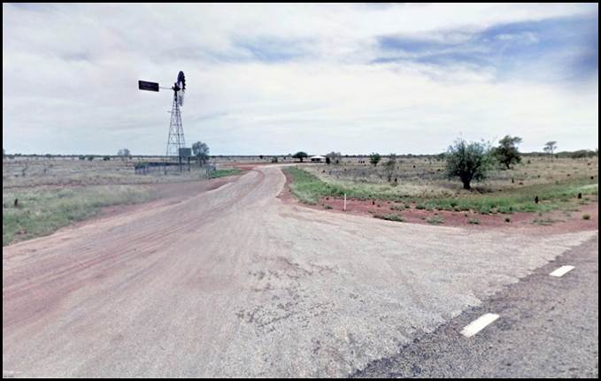
A recent view of Bore 6A at the former Frewena Roadhouse site now known as the Barkly Highway Rest Area.
Google Street View image November 2018.
Vaughan Airstrip Tanami Desert 1964
As mentioned above, the Department of Interior DE third order level traverse was established over some of the country covered by Jerry Whitlock’s 1941 southern track across the Tanami Desert (Karlantijpa country) during June, July, and August in 1964. The traverse was established for the Geophysical Branch of the Bureau of Mineral Resources, Geology and Geophysics within the Department of National Development as part of the Bureau’s oil search program. The DE level traverse commenced on the Stuart Highway about 12 kilometres north of Tennant Creek and ran generally west for 470 kilometres to terminate at the junction of the Tanami to Hooker Creek track about 90 kilometres north of Tanami. There were 57 bench-marks along the DE traverse (numbers DE 03 to DE 59 inclusive).
Bench-mark DE 50 was 243.9 miles (392.6 kilometres) west of the Stuart Highway. Immediately to the south of bench-mark DE 50, the 1964 levelling party observed an established landing strip (Vaughan Airstrip). It was used by aircraft involved in a later BMR gravity survey. The landing strip was about 800 metres (2 600 feet) long with the main strip on a bearing of 120/300°.

Gravity meter reading at Vaughan Airstrip circa 1964, with Piper Aztec aircraft in background.
Bureau of Mineral Resources image kindly provided by Dr David Nash.

Diagram of Vaughan Airstrip, Northern Territory.
Bureau of Mineral Resources diagram kindly provided by Dr David Nash.
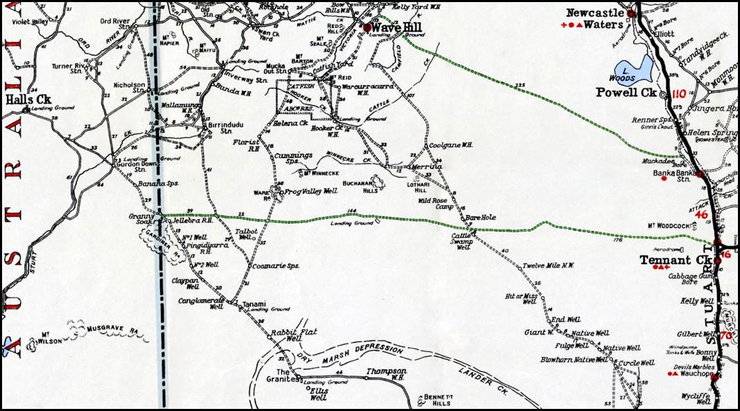
Vaughan Airstrip (landing ground) on Whitlock’s 1941 (southern) track.
HEC Robinson 1953 Northern Territory roadmap annotated by Paul Wise.
Acknowledgements
The author wishes to thank the following people who kindly provided valuable information that greatly assisted with the preparation of this article:
· Mrs Miriam Hagan, formerly of Muckaty Station, Northern Territory, (from 1942 to 1988).
· Dr David Nash, Honorary Senior Lecturer, Linguistics, School of Literature, Languages and Linguistics, Australian National University, Canberra.
· Dr Carlos Pereira de Lemos OAM, former Department of the Interior Technical Officer (Surveying).
· Peter Whitlock, Whitlock Family Association, Canada.
· Colin Fuller AM, former Deputy Commonwealth Surveyor-General (1980-1988).
· Peter Dunn OAM, founder of the Australia @ War web site www.ozatwar.com
· Paul Wise OAM, former Nat Map Senior Surveyor (1969-1999).
· Terry Douglas, former Nat Map Technical Officer (1960-1971).
· Ian Ogilvie, former Nat Map Technical Assistant (1968-1970).
· Harry Baker, former Nat Map pilot and AUSLIG chief pilot.
· Alan Deck, former Nat Map surveyor.
References
Allied Works Council (1943), Report of the Activities of the Allied Works Council for the period 26 February 1942 to 30 June 1943; accessed from the National Library of Australia at: https://nla.gov.au/nla.obj-52824925/view?partId=nla.obj-98158208#page/n0/mode/1up
Anonymous (1924), John Vincent Colquhoun (Ena Whitlock’s father) death notice; in the Family Notices section of The Sun (Sydney), Sunday 3 August 1924, page 9; accessed from the National Library of Australia Trove search service at: https://trove.nla.gov.au/newspaper/article/222318430
Anonymous (1934), Assault on Lubra - Trial of Constable - Charge Outcome of Inquiry (mentions Tracker Donegan, Borroloola); a report in the Kalgoorlie Miner (WA), Thursday 19 April 1934, page 4; accessed from the National Library of Australia Trove search service at: https://trove.nla.gov.au/newspaper/article/95038812
Anonymous (1938), In Divorce, (decree absolute - Richard Henry Lucas v Mary Ena Lucas), a report in The Sydney Morning Herald, Wednesday 19 October 1938, page 10; accessed from the National Library of Australia Trove search service at: https://trove.nla.gov.au/newspaper/article/17529402
Anonymous (1940), Rush Job on Highway, a report in the News (Adelaide), Saturday 24 August 1940, page 4, accessed from the National Library of Australia Trove search service at: https://trove.nla.gov.au/newspaper/article/131422663
Anonymous (1948), Around Town…Mrs Ena Whitlock from Frewena…a snippet in the Centralian Advocate (Alice Springs), Friday 23 January 1948, page 9; accessed from the National Library of Australia Trove search service at: https://trove.nla.gov.au/newspaper/article/59653312
Anonymous (1949), Around The Territory - Newcastle Waters (Map Making) and Elliott, reports in the Northern Standard (Darwin), Friday 5 August 1949, page 6; accessed from the National Library of Australia Trove search service at: https://trove.nla.gov.au/newspaper/article/49990150
Anonymous (1949 A), Brunette Downs Races Successful Meeting Held, a report in the Centralian Advocate (Alice Springs), Friday 15 July 1949, page 3; accessed from the National Library of Australia Trove search service at: https://trove.nla.gov.au/newspaper/article/59857716
Anonymous (1949 B), Astro Survey of Northern Territory, a report in The Advertiser (Adelaide), Wednesday 9 November 1949, page 10; accessed from the National Library of Australia Trove search service at: https://trove.nla.gov.au/newspaper/article/35776165
Anonymous (1951), Diana’s Diary, a snippet about Mrs Gerry Whitlock, late of Frewena; in the Northern Standard (Darwin), Friday 2 November 1951, page 4, accessed from the National Library of Australia Trove search service at: https://trove.nla.gov.au/newspaper/article/49477041
Anonymous (1978), Highway Surveyor dies at age 80, Jerry Whitlock obituary, published in the Centralian Advocate ( Alice Springs), 1 June 1978; accessed from the Whitlock Family Association web site at: http://whitlockfamilyassociation.com.s3.amazonaws.com/sources/newspapers/NP0855.pdf
Anonymous (2018), Honorary Consul of Portugal in Melbourne decorated by the Government of Australia, an article about Carlos Pereira de Lemos, (translated from Portuguese); accessed at: https://ominho.pt/consul-honorario-de-portugal-em-melbourne-condecorado-pelo-governo-da-australia/
Anonymous (undated), Wilfred Hercy Whitlock, a short biographical note; accessed from the Whitlock Family Association web site at: http://whitlockfamilyassociation.com.s3.amazonaws.com/sources/miscellaneous/X3625.pdf
Australian Survey Office (1986), Gravity Traverse Descriptions and related material for 1964 DD, DE and DJ traverses in the Tanami Desert, Northern Territory; digital files of photo copied Bureau of Mineral Resources, Geology and Geophysics material kindly provided by Dr David Nash in July 2021.
Baker, Harry William (2021), Personal communications.
Ball, Desmond John; and Langtry John Osborne (Editors) (1990), The Northern Territory in the Defence of Australia: Geography, History, Economy, Infrastructure and Defence Presence; Australian National University, Strategic and Defence Studies Centre, Coral Bell School of Asia Pacific Affairs, ANU College of Asia and the Pacific, Canberra; accessed at: http://sdsc.bellschool.anu.edu.au/experts-publications/publications/3183/northern-territory-defence-australia-geography-history
Barnes, Rodger Donald (2013), Building an Implementation Framework for Agreements with Aboriginal Landowners: A Case Study of The Granites Mine; a University of Queensland Master of Philosophy thesis, accessed at: http://www.nintione.com.au/resource/BarnesR_ImplementationFrameworkAgreementsAboriginalLandownersGranitesMine_MPhil.pdf
Bureau of Mineral Resources (1964), 1964 Programme, Oil Search, Geophysical Branch (continued), page 6; Bureau of Mineral Resources, Geology and Geophysics Canberra ACT; accessed at: https://d28rz98at9flks.cloudfront.net/11433/Rec1964_177.pdf
Carment, David; Edward, Christine; James, Barbara; Maynard, Robyn; Powell, Alan; and Wilson, Helen J (Editors) (2008), Northern Territory Dictionary of Biography, Revised Edition 2008, Charles Darwin University Press, Darwin, NT : https://dcarment.files.wordpress.com/2014/09/ntdictionaryofbiography.pdf
Chewings, Charles (1930), A Journey from Barrow Creek to Victoria River, an article in The Geographical Journal, Volume 76, No. 4, October 1930, pages 316-338. Published by The Royal Geographical Society (with the Institute of British Geographers), London.
Commonwealth of Australia (1946), Granting of Storekeeper's Licence, Frewena by the Northern Territory of Australia, Licensing District of Central Australia, promulgated in the Commonwealth of Australia Gazette, Issue No 145, Thursday 8 August 1946, page 2124; accessed from the National Library of Australia Trove search service at: https://trove.nla.gov.au/newspaper/article/232893822
Commonwealth of Australia (1960), The Northern Territory of Australia: Land available for leasing situate on the Barkly Highway; notification in the Commonwealth of Australia Gazette, Issue No 65, Thursday 22 September 1960, page 3328; accessed from the National Library of Australia Trove search service at: https://trove.nla.gov.au/newspaper/article/240550206
Dawes, Allan Wesley (1942), Woman is Outback Pioneer; an article in The Daily News (Perth), Wednesday 15 July 1942, page 4; accessed from the National Library of Australia Trove search service at: https://trove.nla.gov.au/newspaper/article/78281025
Deck, Alan James (2021) Personal communication.
de Lemos, Carlos Pereira (2016), Historia de uma Vida (Story of a Life), Chapter VIII – Australia; an autobiography, Chiado Editora, Portagul; ISBN 979-989-51-7549-9
de Lemos, Carlos Pereira (2021), Personal communications, via Paul Wise.
Department of Veterans’ Affairs (undated), Watts, James Barclay Service Number DX3, World War Two Service, Veteran Details; accessed from Department of Veterans’ Affairs, World War Two Nominal Rolls at: https://nominal-rolls.dva.gov.au/veteran?id=843895&c=WW2
Department of Veterans’ Affairs (undated A), Glastonbury, Francis Oliver Service Number S112447, World War Two Service, Veteran Details; accessed from Department of Veterans’ Affairs, World War Two Nominal Rolls at: https://nominal-rolls.dva.gov.au/veteran?id=717615&c=WW2
Douglas, Terry Llewellyn (2021), Personal communications.
Dunn, Peter James (2015), Bore 6a Staging Camp Barkly Highway, NT during WWII, an article on the Australia at War website; accessed at: https://www.ozatwar.com/locations/6abore.htm
Dunn, Peter James (2021), Personal communications.
Flavelle, Alan J (1965), Helicopter survey by contract, NT and Qld 1965, Part I; Record No 1965/212, Bureau of Mineral Resources, Geology and Geophysics, Department of National Development, Canberra, ACT; accessed from Geoscience Australia web site at: http://pid.geoscience.gov.au/dataset/ga/11665
Fuller, Colin Albert (2021), Personal communications, via Paul Wise.
Gard, Ronele; and Gard, Eric (2004), Canning Stock Route: A Travellers Guide, Third Edition, reprinted March 2009; Western Desert Guides, Wembley Downs, WA.
Haigh, Les (2017), The Tontine Street Air Raid 25th May 1917; an article accessed from the Les Haigh web site at: http://www.leshaigh.co.uk/folkestone/tontineraid.html
Harrod, Yvonne Joan (undated), Wilfred Hercy Whitlock a brief biographical article, in Various Bio Notes - Wilfred Hercy Whitlock on the Ancestry web site; accessed at https://www.ancestry.com/mediaui-viewer/tree/20031184/person/262250005715/media/5192509c-3cd8-40cc-8876-084e2503a0a3
Hagan, Miriam Anne (2021), Personal communications.
Hocking, David Roy (1985), Star Tracking for Mapping - An account of astrofix surveys by the Division of National Mapping during 1948-52. Paper 3 presented at the Institution of Surveyors, Australia, 27th Australian Survey Congress, Reducing Remoteness, held at Alice Springs during 23-29 March 1985; accessed from the XNatmap web site at: http://www.xnatmap.org/adnm/ops/prog/astro_new.pdf
Johnson, Howard Angas (1980), Letter to David Nash, a digital copy of which Dr David Nash kindly provided to the XNatmap web site in 2013.
Kowald, Margaret (1990), Transcript of Interview with James Watts, recorded June 1990 in Brisbane; accessed from Northern Territory Archives Service - Oral History Unit at: http://oralhistoryaustraliasant.org.au/wp-content/interviews/transcripts/Transcript-TP747-James%20Watts.pdf
Library and Archives Canada (undated), Whitlock, Wilfred Hercy Regimental Number 736712, file in Personnel Records of the First World War; accessed from Library and Archives Canada web site at: https://www.bac-lac.gc.ca/eng/discover/military-heritage/first-world-war/personnel-records/Pages/item.aspx?IdNumber=307801
Library and Archives Canada (undated A), Lest We Forget: Information Package First World War; accessed from Library and Archives Canada web site at: https://www.bac-lac.gc.ca/eng/discover/military-heritage/lest-we-forget/Documents/first-world-war-information-package.pdf
Ling, Ted (2011), Commonwealth Government Records about the Northern Territory, Research Guide, National Archives of Australia; accessed from the National Archives of Australia web site at: https://www.naa.gov.au/sites/default/files/2020-02/research-guide-government-records-nt.pdf
Marlowe, Adrian (2013), Remembrance of Times Past in St Marylebone, an article in the St Marylebone Society Newsletter, Spring 2013, Number 337, page 6; accessed at: http://www.stmarylebonesociety.org/picts/news337.pdf
Moore, Cameron (2017), Crown and Sword: Executive Power and the Use of Force by the Australian Defence Force; Australian National University Press, Canberra; accessed at: https://press.anu.edu.au/publications/crown-and-sword
National Archives Australia (1946), Grazing Licence for Crown Land in the Northern Territory for Wilfred Hercy Whitlock - 12 months ending 30 June 1947; Citation NAA: A89, 1225, Item ID 4345099; reference information only from Record Search on National Archives Australia web site at: https://recordsearch.naa.gov.au/SearchNRetrieve/Interface/SearchScreens/BasicSearch.aspx
Nash, David (1992), Warlmanpa language and country, (September 1992 draft), an article posted at https://www.anu.edu.au/linguistics/nash/papers/lgshift.pdf
Nash, David (1999), Karlantijpa country, northern central Australia, (1 September 2001 update), an article posted at http://www.anu.edu.au/linguistics/nash/kt/
Nash, David (2001), History of Karlantijpa country, northern central Australia, (27 June 2021 update), an article posted at https://www.anu.edu.au/linguistics/nash/kt/history.html
Nash, David (2005), Whitlock tracks 1941-42, (18 May 2021 update), an article posted at https://www.anu.edu.au/linguistics/nash/kt/Whitlock.html
Nash, David (2008), 1909 Chewings and 1910 Ross, (16 May 2021 update), an article posted at https://www.anu.edu.au/linguistics/nash/kt/1909-chewings.html
Nash, David (2021), 1965 Wongela Geophysical helicopter gravity survey, an article posted at http://www.anu.edu.au/linguistics/nash/kt/1965-Wongela.html
Nash, David (2021 A), 1964 Vaughan and de Lemos levelling traverse, an article posted at http://www.anu.edu.au/linguistics/nash/kt/1964-traverse.html
Nash, David (2021 B), Personal communications.
New South Wales Government (1938), Notice of Granting of Gold Mining Leases, in the Government Gazette of the State of New South Wales, Issue No 46, Friday 25 March 1938, page 1275; accessed from the National Library of Australia Trove search service at: https://trove.nla.gov.au/newspaper/article/225071259
New South Wales Government (1944), Notice of Mining Lease Application Refusal, in the Government Gazette of the State of New South Wales, Issue No 83, Friday 18 August 1944, page 1432; accessed from the National Library of Australia Trove search service at: https://trove.nla.gov.au/newspaper/article/225097586
New South Wales Government (1947), Notice of Mining Lease Cancellation, in the Government Gazette of the State of New South Wales, Issue No 31, Friday 28 February 1947, page 497, accessed from the National Library of Australia Trove search service at: https://trove.nla.gov.au/newspaper/article/224766651
New South Wales Government (undated), Whitlock Wilfred H D, birth registration no: 15887/1898, father William W L, mother Florence C, district St Leonards; Family history (Births) search result from NSW Registry of Births Deaths and Marriages web site at: https://familyhistory.bdm.nsw.gov.au/lifelink/familyhistory/search/births?
New South Wales Government (undated A), Colquhoun Mary E, registration number: 26002/1907, father John, mother Johanna A, district Marrickville; Family history (Births) search result from NSW Registry of Births Deaths and Marriages web site at: https://familyhistory.bdm.nsw.gov.au/lifelink/familyhistory/search/births?
New South Wales Government (undated B), Lucas Richard H, groom, Colquhoun Mary E, bride, district Rockdale, marriage registration number: 11355/1928; Family history (Marriages) search result from NSW Registry of Births Deaths and Marriages web site at: https://familyhistory.bdm.nsw.gov.au/lifelink/familyhistory/search/marriages?
New South Wales Government (undated C), Whitlock Wilfred Hercy, groom, Lucas Mary Ena, bride, marriage registration number 7298/1941, district Sydney; Family history (Marriages) search result from NSW Registry of Births Deaths and Marriages web site at: https://familyhistory.bdm.nsw.gov.au/lifelink/familyhistory/search/marriages?
Northern Territory Library (undated), The Track: 1000 Miles to War – Barkly Highway; accessed at: http://www.ntlexhibit.nt.gov.au/exhibits/show/track/barkly
Office of the Aboriginal Land Commissioner (1997), Warlmanpa (Muckaty Pastoral Lease) Land Claim No 135, Report No 51, Report and Recommendation of the Aboriginal Land Commissioner; under the Aboriginal Land Rights (Northern Territory) Act 1976; accessed at: https://web.archive.org/web/20140225043354/http:/www.dss.gov.au/sites/default/files/documents/05_2012/51.pdf
Ogilvie, Ian Francis (2021), Personal communications.
Queensland Government (2014), Mount Isa-Camooweal-Tennant Creek Defence Road, in Queensland World War II Historic Places; accessed at: https://www.ww2places.qld.gov.au/place?id=1065
Robinson, Herbert Edward Cooper (1953), Northern Territory road map, compiled and published by H E C Robinson Pty Ltd, Sydney; accessed from the National Library of Australia at: https://nla.gov.au/nla.obj-234121977/view
Smith, George (undated), Charles Chewings, an entry on the South Australian Museum web site; accessed at: https://www.samuseum.sa.gov.au/collection/archives/provenances/aa-59
Various (various dates), Wilfred Hercy Dominick Whitlock; search results for family tree, electoral roll, and other biographical information on Ancestry website; accessed from: https://www.ancestry.com.au/
Wellman, Peter; Barlow, BC; and Murray, AS (1985), Gravity Base-station Network Values, Australia; Report 261, Bureau of Mineral Resources, Geology and Geophysics; Department of Resources and Energy; Australian Government Publishing Service, Canberra 1985; accessed at: https://dokument.pub/gravity-base-station-network-values-australia-flipbook-pdf.html
Whitlock, Mary Ena (1951), Frewena for Sale, an advertisement in the Centralian Advocate (Alice Springs), Friday 24 August 1951, page 4; accessed from the National Library of Australia Trove search service at: https://trove.nla.gov.au/newspaper/article/59840901
Whitlock, Mrs (1898), Advertisement for general domestic help; in The Daily Telegraph (Sydney), Wednesday 23 March 1898, page 12; accessed from the National Library of Australia Trove search service at: https://trove.nla.gov.au/newspaper/article/238367613
Whitlock, Peter (2021), Personal communication.
Whitlock, WL (1895), If you would have beautiful teeth hasten to Mr WL Whitlock, Sydney Dental Rooms; an advertisement in The Dawn (Sydney) Saturday 1 June 1895, page 8; accessed from the National Library of Australia Trove search service at: https://trove.nla.gov.au/newspaper/article/76419335
Wise, Paul Joseph (2021), Personal communications.